


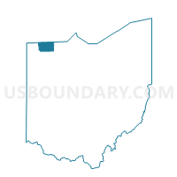
AMBOY, Fulton County, Ohio
About
Outline

Summary
| Unique Area Identifier | 646566 |
| Name | AMBOY |
| County | Fulton County |
| State | Ohio |
| Area (square miles) | 25.10 |
| Land Area (square miles) | 25.01 |
| Water Area (square miles) | 0.09 |
| % of Land Area | 99.66 |
| % of Water Area | 0.34 |
| Latitude of the Internal Point | 41.69284580 |
| Longtitude of the Internal Point | -83.92802540 |
Maps


Graphs
Select a template below for downloading or customizing gragh for AMBOY, Fulton County, Ohio


Neighbors
Neighoring Voting District (by Name) Neighboring Voting District on the Map
- Voting District 0912702000001, Lenawee County, MI
- Voting District 0916026000001, Lenawee County, MI
- Voting District 0916858000001, Lenawee County, MI
- FULTON, Fulton County, OH
- METAMORA, Fulton County, OH
- PIKE, Fulton County, OH
- RICHFIELD 1 Voting District, Lucas County, OH
- ROYALTON, Fulton County, OH
- SPENCER 1 Voting District, Lucas County, OH
Top 10 Neighboring County Subdivision (by Population) Neighboring County Subdivision on the Map
- Fulton township, Fulton County, OH (3,182)
- Spencer township, Lucas County, OH (1,882)
- Pike township, Fulton County, OH (1,854)
- Amboy township, Fulton County, OH (1,846)
- Fairfield township, Lenawee County, MI (1,764)
- Richfield township, Lucas County, OH (1,598)
- Royalton township, Fulton County, OH (1,515)
- Riga township, Lenawee County, MI (1,406)
- Ogden township, Lenawee County, MI (973)
Top 10 Neighboring Place (by Population) Neighboring Place on the Map
Top 10 Neighboring Unified School District (by Population) Neighboring Unified School District on the Map
- Evergreen Local School District, OH (7,578)
- Blissfield Community Schools, MI (7,144)
- Sand Creek Community Schools, MI (3,701)
Top 10 Neighboring State Legislative District Lower Chamber (by Population) Neighboring State Legislative District Lower Chamber on the Map
- State House District 46, OH (127,690)
- State House District 74, OH (118,430)
- State House District 57, MI (94,159)
Top 10 Neighboring State Legislative District Upper Chamber (by Population) Neighboring State Legislative District Upper Chamber on the Map
- State Senate District 2, OH (363,296)
- State Senate District 1, OH (351,303)
- State Senate District 16, MI (253,123)
Top 10 Neighboring 111th Congressional District (by Population) Neighboring 111th Congressional District on the Map
- Congressional District 7, MI (676,899)
- Congressional District 5, OH (627,799)
- Congressional District 9, OH (619,010)
Top 10 Neighboring Census Tract (by Population) Neighboring Census Tract on the Map
- Census Tract 405, Fulton County, OH (4,899)
- Census Tract 621, Lenawee County, MI (4,408)
- Census Tract 401, Fulton County, OH (3,286)
- Census Tract 620, Lenawee County, MI (2,897)
- Census Tract 94, Lucas County, OH (2,616)
- Census Tract 93, Lucas County, OH (1,598)
Top 10 Neighboring 5-Digit ZIP Code Tabulation Area (by Population) Neighboring 5-Digit ZIP Code Tabulation Area on the Map
- 43558, OH (13,579)
- 43515, OH (7,979)
- 49228, MI (5,545)
- 43533, OH (1,553)
- 43540, OH (1,501)
- 43504, OH (1,094)
- 49248, MI (899)